RigModels.com Logo
100,000+ Free Models Search Engine.
10,000+ Animations.
Rig & Animate Models Automatically.
Search 3D Models
Search


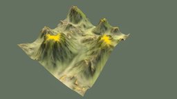
  Mountain House at Hill 3D Model 2025-05-06
House Low Poly 3d model
Mountain House at Hill house 360
  Faces :438 Textured :Yes (4) Animated :No
  Vertices :392 UV Mapping :Yes License : Royalty Free
Model's Description:
Mountain House at Hill 3D Model, Fully textured with UV Mapping and materials.
Download Mountain House at Hill in various files formats such as Wavefront Object format, Autodesk FBX, DirectX 9.0, Stereo Lithography and HTML5 JSON format.
House Low Poly 3D Model is ready to download for free with 4 Texture files attached, this model contains 438 polygons and 392 vertices.
Model's rating is (3.5) based on 266 Votes.
  Download :   (12,483 Hits)


   Print 3D Model :


   Simplify This Model :


Tags:  mountain, hill, house, home, store, stairs, stairway, way, farm, country, hut, cottage, structure, lowpoly,
  Related Models:
 Bike
Bike bike, wheel, bicycle, frame, transportation, seat, cycle, sports, mountain, mtb, bycycle, off-road, atb, racing, sport, race
Model's Description:
Bike 3D Model, Optimized by RigModels.com, Fully textured with UV Mapping and materials. Download Bike in various files formats such as Wavefront Object format, Autodesk FBX, DirectX 9.0, Stereo Lithography and HTML5 JSON format.
Detailed 3d model of modern bike. 3D Model is ready to download for free, this model contains 140020 polygons.
 140,020 polygons  Download 
 
 Jabal Tuwaiq Mountain, Ri
Jabal Tuwaiq Mountain, Riyadh, Saudi Arabia archeology, historical, mountain, landmark, sites, place, tourism, tourist, poi, saudi, riyadh, arabia, visit, sheer, clif, photogrammetry, jabal, tuwaiq
Model's Description:
Jabal Tuwaiq Mountain, Riyadh, Saudi Arabia 3D Model, Optimized by RigModels.com, Fully textured with UV Mapping and materials. Download Jabal Tuwaiq Mountain in various files formats such as Wavefront Object format, Autodesk FBX, DirectX 9.0, Stereo Lithography and HTML5 JSON format.
Jabal Tuwaiq (Arabic: جَبَل طُوَيْق, Tuwaiq Mountain) is a narrow escarpment that cuts through the plateau of Najd in central Arabia, running approximately 800 km (500 mi) from the southern border of Al-Qasim in the north, to the northern edge of the Empty Quarter desert near Wadi ad-Dawasir in the south. It is 600 m (2,000 ft) high and also has a Middle Jurassic stratigraphic section. The eastern side slopes downwards gradually, while the western side ends in an abrupt manner. The escarpment can be thought of as a narrow plateau, though the locals refer to it as a jebel (“mount”). Marshall Cavendish used the name “Tuwayr Mountains” to describe mountains of central Arabia, distinct from the Shammar in the north, the Dhofar in the south, and the Hajar to the east. Many narrow valleys (wadis) run along its sides, such as Wadi Hanifa, and a group of towns lie on its central section, including the Saudi capital, Riyadh. Many settlements have historically existed on either side of it as well… Wikipedia.org 3D Model is ready to download for free, this model contains 248750 polygons.
 248,750 polygons  Download 
 
 Terrain 017
Terrain 017 planet, landscape, forest, terrain, canyon, land, mars, ice, exterior, hill, grand, desert, snow, valley, cliff, mountains, stone, fantasy, rock, environment
Model's Description:
Terrain 017 3D Model, Optimized by RigModels.com, Fully textured with UV Mapping and materials. Download Terrain 017 in various files formats such as Wavefront Object format, Autodesk FBX, DirectX 9.0, Stereo Lithography and HTML5 JSON format.
3D Model is ready to download for free, this model contains 1019592 polygons.
 1,019,592 polygons  Download 
 
 WWII Radar Station, Ward
WWII Radar Station, Ward Hill, Fair Isle ww2, antenna, scotland, wwii, naval, radar, cdu, kite-aerial-photography, shetland-isles, meta_geo, 2017, metashape, agisoft, coast-defence, chain-home-low, fair-isle, ward-hill, geo_gfwffb50qrgz
Model's Description:
WWII Radar Station, Ward Hill, Fair Isle 3D Model, Optimized by RigModels.com, Fully textured with UV Mapping and materials. Download WWII Radar Station in various files formats such as Wavefront Object format, Autodesk FBX, DirectX 9.0, Stereo Lithography and HTML5 JSON format.
A WWII radar station on Ward Hill, Fair Isle, it was a Coast Defence U-boat (C.D.U.) station which was the naval version of the R.A.F.’s Chain Home Low (C.H.L.) radar. Radar was used here to track shipping and surfaced submarines and at longer distances aircraft. Something that makes this site unusual is that parts of the antennas and their turntables still survive here. After the war the site was partially dismantled then some buildings/structures blown up with explosives. Damage to the floors indicate where some of the charges were set. Fair Isle is situated about half way between the Orkney Isles and the Shetland Isles off the north coast of Scotland. Grid Reference: HZ 209 734 Photographed: 22 August 2017 Model created: December 2018 with some additional processing in April 2020 using Agisoft MetaShape 3D Model is ready to download for free, this model contains 1999999 polygons.
 1,999,999 polygons  Download 


Download Free 3D Models - Animated Models - Privacy Policy - RSS
Copyright © 2017-2025 RigModels. All rights reserved.
Contact Info